Johnson City
The other end of the Tweetsie Trail, with ETSU and Founders Park.
Community guide · Tennessee
A Carter County seat where an 1882 covered bridge spans the Doe River downtown, and the Watauga River at Sycamore Shoals carries a separate chapter of early American history.
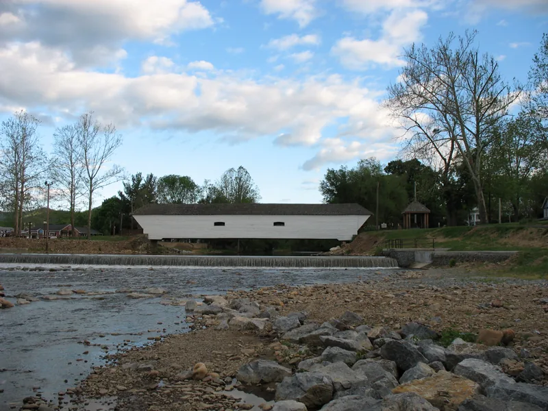
Elizabethton's geography explains the town. The Doe River runs through downtown, beneath the city's covered bridge and alongside Covered Bridge Park. The Watauga River is the setting for Sycamore Shoals, where some of the most consequential events of the region's settlement took place. They are different rivers and different places, and each deserves its own visit.
At Sycamore Shoals in 1775, Richard Henderson's Transylvania Company concluded a vast and contested land purchase from the Cherokee. The following summer, settlers at nearby Fort Watauga withstood a siege of about two weeks. On September 25, 1780, the Overmountain Men gathered at the shoals before marching across the mountains toward the Battle of Kings Mountain.
Today's Sycamore Shoals State Historic Park interprets that history with a visitor center, river trails and a reconstruction of Fort Watauga; the original fort stood about a mile away.
Elizabethton's Covered Bridge has crossed the Doe River downtown since the early 1880s. The City dates it to 1882, while some historical records describe an 1882–1884 construction period. The wooden span has outlasted repeated floods, including the devastating Doe River flooding of Hurricane Helene in September 2024, which destroyed homes, businesses and bridges upstream.
The bridge is the centerpiece of Covered Bridge Park, a riverside green that hosts community gatherings, including the annual Covered Bridge Days festival and the city's Fourth of July celebration. After Helene, the nearby 1929 Broad Street Bridge over the Doe closed for repairs and reopened on July 2, 2025.
Recovery work in the area has continued since the storm. For any property, current conditions and repairs are worth confirming directly rather than assumed.
Elizabethton was founded in 1799 and has long served as the seat of Carter County. The Elizabethton Historic District, listed on the National Register in 1973, covers the downtown core, with properties from the late 1700s through the 1930s, including Federal and late-Victorian architecture. Elk Avenue runs through its heart, and the Soldiers' Monument stands at the circle where Elk Avenue meets Main Street.
Downtown's twentieth-century chapter is visible too. The Bonnie Kate Theatre, a 1926 movie house, was purchased by the City in 2016 for restoration as a community performance space. Main Street Elizabethton publishes downtown maps of landmarks, businesses and the Tweetsie Trail connection.
Main Street Elizabethton: downtown maps · City of Elizabethton
On a rise near Sycamore Shoals stands Sabine Hill, a frame Federal-style house begun by General Nathaniel Taylor after the War of 1812. He died in 1816, and his widow, Mary Patton Taylor, completed the house around 1818. The Tennessee Historical Commission acquired it in 2008, restored it and offers tours through Sycamore Shoals State Historic Park. Also on the Sycamore Shoals grounds is the Carter Mansion, built between about 1775 and 1780, which is often described as the oldest frame house in Tennessee.
In the 1920s, German-affiliated rayon plants brought large-scale industry to Elizabethton. In the spring of 1929, workers at the American Glanzstoff and Bemberg plants walked out in strikes that drew national attention and remain a significant chapter in Southern labor history.
About 9.5 miles on the former East Tennessee & Western North Carolina Railroad corridor, linking Elizabethton and Johnson City and passing near Sycamore Shoals on the Elizabethton end.
River trails that combine walking with history, plus the visitor center, Fort Watauga reconstruction and Sabine Hill tours.
Downtown green space beside the Doe and the home of community festivals.
Mountain recreation is within reach of Carter County. Access varies by site and season, and some areas were affected by Hurricane Helene, so check conditions with the managing agency.
Older homes near downtown, including properties within the historic district.
Mid-twentieth-century homes associated with the town's industrial growth.
Subdivisions and newer homes toward the edges of town.
Properties where wells, septic systems, private roads and slope affect the review.
Some homes sit near the Doe or Watauga rivers or their tributaries. Proximity to water says nothing definitive about a particular property's flood risk, insurance or access; those are parcel-specific questions answered by FEMA flood maps, elevation information, insurance quotes and the local floodplain administrator.
Elizabethton connects to Johnson City by U.S. 321 and the U.S. 19E corridor, and by the Tweetsie Trail for walkers and cyclists. Tri-Cities Airport in Blountville serves the region. Check current road conditions with TDOT before relying on any route, as Helene repairs have affected some corridors.
An Elizabethton address may be inside city limits or in unincorporated Carter County. Jurisdiction affects taxes, services, regulations and the school system, so we confirm it early.
The National Register listing is honorary. A separate local historic-zoning district covers part of downtown and requires approval for major exterior changes. Confirm current boundaries with the City.
Check flood-zone status, elevation and an insurance quote for the specific parcel. Do not assume from distance to a river.
Tennessee assesses residential property at 25% of appraised value; city residents pay city and county rates. Electric service in much of the area is provided by the Elizabethton Electric Department, and the City operates water resources; confirm all providers, including natural gas and internet, for the exact address.
Elizabethton Electric Department · FCC National Broadband Map
Elizabethton City Schools and Carter County Schools are separate systems, and assignment is by address; some schools inside city limits belong to the county system. Confirm the zone for the specific property with each district. This is a directory, not a ranking.
The Doe River. The Watauga River, at Sycamore Shoals, is a separate river and historic site.
The City dates it to 1882. Some historical records describe construction spanning 1882 to 1884.
Not necessarily. Flood status is parcel-specific. Check the FEMA flood map for the address and ask for an insurance quote before you buy.
No. Confirm jurisdiction with county property records; it affects taxes, services and the school system.
Yes. The Tweetsie Trail connects Elizabethton and Johnson City on a former rail corridor, about 9.5 miles end to end.
A Federal-style house completed around 1818 by Mary Patton Taylor, restored by the Tennessee Historical Commission and open for tours through Sycamore Shoals State Historic Park.
From a home near downtown to a property in the Carter County countryside, I can help you work through the questions that matter for a specific address, including jurisdiction and flood information.
Talk with MarshallFacts were checked against official city, state and institutional sources in October 2026. Event schedules, trail access and post-flood repairs change; confirm current details with the listed sources.
Historical source records; external links and facts require an updated review before production use.
Plan your next step: First-time homebuyer guide · Preparing to sell your home · Moving to the Tri-Cities · Explore community guides